Collaboration diagram for argr_type:
Data Fields | |
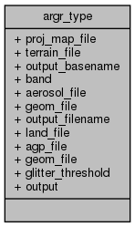
| char * | proj_map_file |
| char * | terrain_file |
| char * | output_basename |
| int | band |
| char * | aerosol_file |
| char * | geom_file |
| char * | output_filename |
| char * | land_file |
| char | agp_file [MAX_FILENAME] |
| char | geom_file [MAX_FILENAME] |
| float | glitter_threshold |
| int | output |
Detailed Description
Definition at line 35 of file MtkL1B2Reproject.c.
Field Documentation
◆ aerosol_file
| char* argr_type::aerosol_file |
Definition at line 37 of file MtkL2ASCloudMaskReproject.c.
◆ agp_file
| char argr_type::agp_file[MAX_FILENAME] |
Definition at line 50 of file MtkSurfaceBRFRegression.c.
◆ band
| int argr_type::band |
Definition at line 39 of file MtkL1B2Reproject.c.
◆ geom_file [1/2]
| char* argr_type::geom_file |
Definition at line 39 of file MtkResampleGeom.c.
◆ geom_file [2/2]
| char argr_type::geom_file[MAX_FILENAME] |
Definition at line 51 of file MtkSurfaceBRFRegression.c.
◆ glitter_threshold
| float argr_type::glitter_threshold |
Definition at line 52 of file MtkSurfaceBRFRegression.c.
◆ land_file
| char* argr_type::land_file |
Definition at line 47 of file MtkSurfaceBRFRegression.c.
◆ output
| int argr_type::output |
Definition at line 55 of file MtkSurfaceBRFRegression.c.
◆ output_basename
| char * argr_type::output_basename |
Definition at line 38 of file MtkL1B2Reproject.c.
◆ output_filename
| char* argr_type::output_filename |
Definition at line 40 of file MtkResampleGeom.c.
◆ proj_map_file
| char * argr_type::proj_map_file |
Definition at line 36 of file MtkL1B2Reproject.c.
◆ terrain_file
| char * argr_type::terrain_file |
Definition at line 37 of file MtkL1B2Reproject.c.
The documentation for this struct was generated from the following files:
- applications/MtkL1B2Reproject.c
- applications/MtkL2ASCloudMaskReproject.c
- applications/MtkResampleGeom.c
- applications/MtkSurfaceBRFRegression.c